CALLA JORDAN / MANAGING EDITOR
This winter, San Diego will experience its first “super” El Niño of the century. The climate pattern, coined by a South American fisherman, is the warm phase of the El-Niño-Southern Oscillation (ENSO). The fisherman noticed the changing ocean temperatures during the Christmas season and cited the phenomenon as “El Niño” — “Christ Child” in Spanish.
According to the National Oceanic and Atmospheric Administration (NOAA), southern coasts will face a wetter, more humid season than usual, with risks of storms and flooding, while northern areas of the U.S. are expected to experience drier weather.
The 2026 El Niño climate pattern is predicted to be exceptionally strong, classifying as a “super” El Niño.
USD professor of environmental and ocean sciences Zhi-Yong Yin highlighted the likely effects of the event and potential secondary geohazards.
“It’s almost certain that we’re going to see more rainfall [and] more storms this time, and probably the warming sea surface temperature along the coast will last a bit longer into next spring,” Yin shared. “Whenever we have storms in Southern California, we expect mudslides and landslides. If we have a good rainy season, we [will] probably have better vegetation growth, and then for the following year during the dry season, there might be bigger wildfires if that happens.”
While the culmination of an El Niño year and the prevailing effects of climate change have raised many concerns among West Coast residents, their correlation remains uncertain.
“Some people are saying that with climate change we probably will see stronger El Niño events in [the] future, but that’s not entirely conclusive at this point,” Yin continued. “But the one thing that we’re pretty sure is with global warming… the global temperature is increasing, and then during El Niño years, it’s going to enhance the warming even more.”
According to San Diego Coastkeeper, the city of San Diego is familiar with rainfall during the wet season — from December through March. During this season, the lack of proper stormwater infrastructure and the San Diego River’s central location makes flooding more likely. The city is in need of a $1.6 billion investment to improve stormwater infrastructure. However, despite the January 2024 floods that resulted in the destruction of many San Diego homes, this improvement remains underfunded.
USD senior Aidan Quinn is originally from the Hawaiian island of Kihei. Like San Diego, the southern side of the island is less prone to hurricanes and intense rainstorms than other areas of the state.
“We have a big mountain that usually the other side takes up all the rain, and we get left with high clouds and no rain,” Quinn shared. “When storms come from the other side, the infrastructure is not really prepared for that much water at one time.”
Quinn echoed similar flaws in San Diego’s urban setup.
“[During rainstorms] Mission Valley floods every time, and Mission Beach floods every time,” Quinn said. “The whole peninsula area as you drive past Belmont Park, that’ll fill up with a foot of water.”
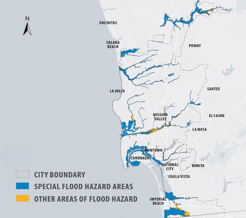
While San Diego is not accustomed to perpetual rainfall, the city has experienced the intense rainfall before, giving residents and city officials advance experience for this event. According to the City of San Diego, Mission Valley, Chollas, Sorrento Valley and the Tijuana River Valley are some of the most prone areas to flooding. Conversely, the University of San Diego, located near the western end of Mission Valley, is less likely to experience intense impacts from the storms due to its elevated position.
“I don’t see major concerns for people living on campus,” Yin noted. “It’s probably just occasional flooding, maybe there are puddles of water all the time. You have to carry your umbrella more times.”
However, some USD students live scattered throughout the city, making it difficult to surmise the impact on their neighborhoods. USD senior Sasha Pasquini noted the importance of accessible resources and information available to students.
“We have a big presence in San Diego, and I feel like there are definitely resources that would be helpful to people who aren’t up on the hill,” Pasquini expressed.
According to The City of San Diego’s government website, city crews are preparing storm drains and other city facilities for the season. Residents are recommended to find their neighborhood flood risk data through the Flood Insurance Map located at Sandiego.gov.
Flood hazard areas in the San Diego Area. Photo courtesy of @cityofsandiego/Instagram

 The USD Vista
Leave a comment